JOURNAL / 2026.08.24
WeatherNext Cyclones opens its hurricane-forecasting weights
Google's model gained more than a day of average accuracy in retrospective evaluations and has already informed real forecasts; opening its weights and code makes the advance examinable, not an automatic official warning.
When a language model improves on a benchmark, the practical consequence may take time to appear. When a cyclone forecast improves, a few hours can change when a team mobilizes, a port closes, or a region evacuates. That difference makes the result from WeatherNext Cyclones especially valuable—and delicate: Google DeepMind has released the code and weights of a model that jointly forecasts track, intensity, and wind extent, and that was already used as guidance during the 2025 Atlantic season.
The paper accepted in Nature attributes an average lead-time advantage of a day or more over operational baselines on cyclones from 2023 through 2025. The system does not merely estimate where the center will go: it produces up to fifteen days of global atmospheric evolution and storm-specific fields for position, maximum wind, pressure, and wind radii. One random sample generates one possible path; many samples form a distribution of scenarios.
The idea breaks through a historical separation. Track depends heavily on global atmospheric currents, which broad models capture well, while intensity emerges from small processes around the core and has usually required much higher-resolution regional models. WeatherNext operates on a grid of roughly 28 kilometers, co-trains on the global atmosphere and targets extracted from the historical cyclone record, and still improves both tasks. It does not show that physical detail has stopped mattering. It does show that a relatively coarse representation contains more useful intensity signal than previously assumed.
A day of advantage is not an extra day of warning
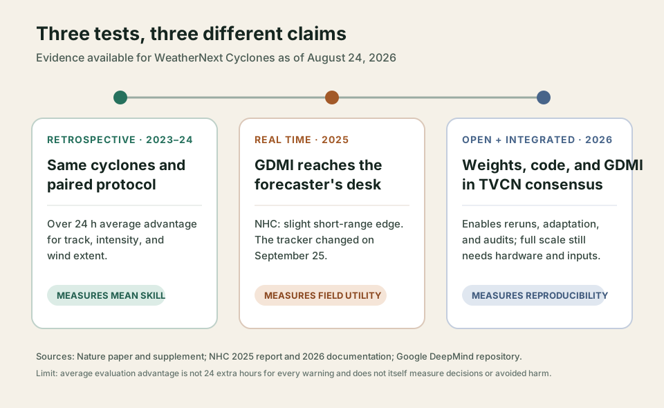
The number needs translation. The authors compare errors on the same cases and ask how much earlier WeatherNext reaches the accuracy another model attains later. In 2023–2024, for example, its ensemble mean reached the same track-error threshold as the ECMWF ensemble with about 27 hours of additional lead time; against the older HWRF, it gained about 40 hours at one intensity-error threshold. The “day” is an aggregate equivalence in forecast skill, not a promise that every warning will be issued 24 hours earlier.
The evaluation is more serious than a selected chart. It pairs only times when every compared model predicts the same active cyclone, uses proper probabilistic scores that reward both accuracy and well-calibrated uncertainty, and estimates significance by resampling whole cyclones. The methodological supplement also acknowledges the advantage that an average of many members has over a deterministic prediction and separately reports probabilistic comparisons.
There are less visible limits. The model learned from atmospheric reanalyses and the IBTrACS archive; the “ground truth” for intensity combines observations that are more incomplete in some oceans and eras than others. Homogeneous comparisons exclude cases that one model did not track as an active cyclone, a standard choice that makes the head-to-head fairer but does not fully measure storm formation or dissipation. And a historical result does not yet prove how a human decision changes under pressure.
That is why the 2025 season matters. WeatherNext began supplying public forecasts in June, and the National Hurricane Center (NHC) used its output—called GDMI after post-processing—alongside other guidance. The official verification report for that season gives a more restrained reading than the headline: GDMI was slightly better for short-range track, while official forecasts generally beat most dynamical and consensus models. Intensity was difficult across the system during a season with several rapid-intensification events.
Nor was this a frozen trial. On September 25, Google changed the tracker that turns network fields into tabular storm paths; the new method reduced jumps and improved wind radii in particular. The paper separately reports the model with the final tracker and what was actually available at each point in 2025. That distinction avoids retrospectively improving a season that had already happened.
The operational evidence therefore does not diminish the result; it locates it. The model produced a useful signal, entered a real process, and was sometimes the best guidance. The forecaster remained the person combining observations, models, and experience into a warning. In 2026, the NHC's verification documentation already lists GDMI among the possible components of its TVCN track consensus. The meaningful integration is not replacing the meteorologist but adding a fast new distribution to the evidence they must judge.
Open weights, incomplete chain
The release allows much more than looking at a chart. The repository distinguishes checkpoints trained only on data preceding each season to reproduce the 2023 and 2024 evaluations, the model used in 2025, and a Mini version. It includes inference code, the tracker, examples, an executable notebook, and access to the weights. The code is under Apache 2.0 and the other materials under CC BY 4.0. Researchers can recompute metrics, inspect failures by basin, change post-processing, or adapt the system to local hazards.
“Open” does not mean simple or fully self-contained. Full models require an H100 GPU or a TPU with enough memory, along with current meteorological initial conditions. Retraining depends on large ECMWF archives and historical datasets governed by their own terms. The Mini version fits on a P100 and can be tested in a free environment, but its authors warn that it does not match the main system.
Speed also needs careful reading. One fifteen-day forecast takes roughly one minute on a TPU v5p. The operational 50-member ensemble is parallelized over 64 devices, and the 1,000-member ensemble uses 256. AI cuts the cost dramatically relative to many high-resolution physical simulations, but a map of a thousand futures does not appear for free on a laptop.
My reading is that the central contribution is not a competition between “AI” and “physics.” WeatherNext depends on observations, reanalyses, numerical models for its initial state, agency-built archives, and meteorologists who interpret its output. What is new is that a network can turn that accumulated scientific infrastructure into a much cheaper global set of scenarios with direct storm signals, at sufficient quality to enter an operational desk.
Opening the weights makes that claim more debatable in the best sense: others can test where it works, where it fails, and whether gains over averages persist for specific decisions. That should be the next standard. Publishing a mean advantage is not enough; each season must be followed, the versions actually used must be preserved, false confidence must be measured, and researchers must study whether the new signal improves warnings and decisions when combined with people. A day of forecast skill can be enormous. Turning it into a day of protection remains the work of the whole system.
Sources
- Google DeepMind, WeatherNext: AI model achieves breakthrough in forecasting cyclones, August 6, 2026.
- Alet et al., Operational Tropical Cyclone Forecasting with AI, Nature, August 6, 2026, and supplementary information.
- Google DeepMind, WeatherNext repository, checkpoints, and licenses, accessed August 24, 2026.
- National Hurricane Center, Forecast Verification Report: 2025 Hurricane Season, March 30, 2026.
- National Hurricane Center, verification model documentation and composition, updated July 8, 2026.