JOURNAL / 2026.08.30
Google automates geospatial prediction with Planetary Prediction Engine
An Earth AI agent searches for data, builds datasets, and trains models in minutes; its health, food, and risk tests are substantive, but the system is not open and validating a prediction remains the decisive work.
During the Bundibugyo virus disease outbreak declared in May in the Democratic Republic of the Congo, a Google Research system received a question, assembled epidemiological and geographic signals, built features, tested models, and produced a risk map. It did not merely summarize reports. It executed the work that turns scattered sources into a prediction.
That is the change introduced by the Planetary Prediction Engine (PPE), presented in an August 26 paper and on the Google Research blog the next day. The system covers three kinds of task—spatial regression, geographic downscaling, and epidemiological prediction—and combines public data with representations already learned by Earth AI's geospatial models. In the Ebola example, it executed 793 steps in three sessions totaling 55.2 minutes.
That figure deserves attention, but it does not mean that a one-hour query produces a health policy ready for use. It measures the runtime of a workflow already built on prior records, platforms, and models. It excludes creating the data, developing the system, reviewing the result, and deploying an intervention. The material contribution is more precise: part of the work that previously required weeks of specialist engineering can become an automated, traceable search for candidate models.
The agent decides what deserves to be a feature
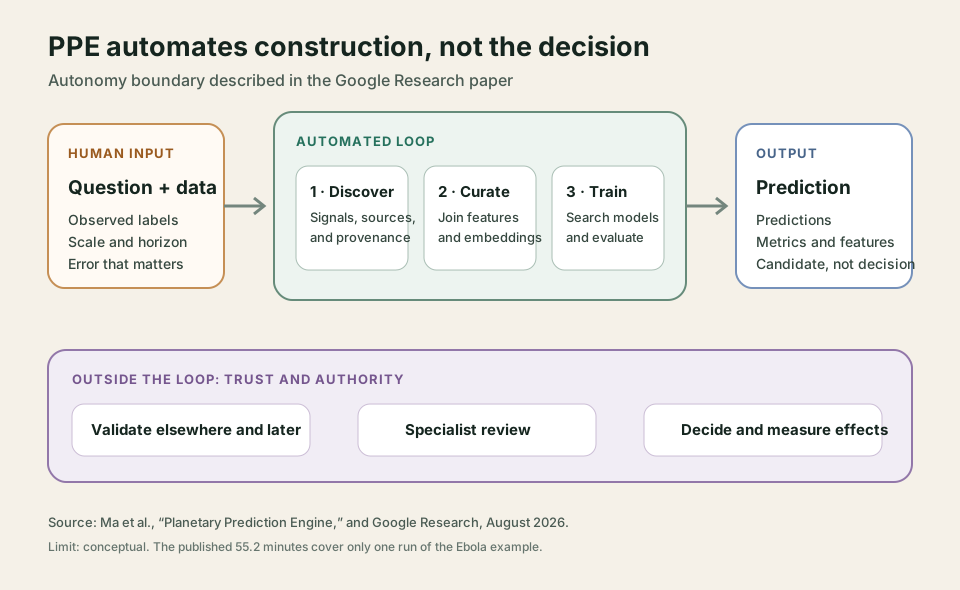
In 2025, Earth AI could already decompose complex questions and consult specialist imagery, population, and environment models. PPE moves one link further. It receives labeled data and a predictive question, identifies spatial and temporal scale, searches literature and official sources for plausible signals, downloads datasets, and joins them. It then combines those variables with Population Dynamics Foundation Model and AlphaEarth embeddings, and compares linear models, trees, and small neural networks under different regularization settings.
The LLM is primarily an orchestrator of tools and decisions. Large artifacts pass between stages through opaque handles rather than inside the model's context. This keeps dataframe size from depending on the token window and separates data search from training. It also lets the system prohibit the prediction agent from returning to the web or changing the dataset once evaluation begins.
Automatic data selection is both the most interesting capability and the main risk. PPE applies a four-rule gate: it excludes variables that are mathematically part of the target, come from the same survey, are a downstream consequence, or belong to the future. It also preserves provenance and licensing. But the system itself judges the causal rule, and the paper acknowledges that it is not formally verified. A variable can pass the gate and still be a local shortcut, a trace of historical inequality, or a correlation that vanishes in another region.
The experiments show why this deserves study. Across 21 CDC health indicators, the full combination achieved a mean R² of 76.8%, compared with 60% for the expert workflow used as a reference. During the Congolese outbreak, the ten zones prioritized by the system each week included 15 of the 18 zones that became invaded over five consecutive forecasts: 83.3% Recall@10, compared with about 73% for the published reference.
The outbreak result is the most persuasive because it respects time order and was developed with researchers from the Institut National de Recherche Biomédicale. It is also narrow. It covers five weeks, one pathogen, and one outbreak; the reported confidence interval around 83.3% runs from 60.8% to 94.2%. Recall@10 asks whether a newly affected zone appeared among ten priorities. It does not measure future case counts, whether resources arrived in time, or whether an infection was prevented. The paper does not claim that PPE made health-response decisions.
Other figures need different boundaries. In Nigeria, the 66.1% R² said to “double” 31.5% compares the complete system with a baseline containing only seasonality and trend; adding vegetation without the full agent already reached 60.1%. Moreover, local ground truth used to validate the downscaling was estimated by another statistical model from surveys representative at a coarser level. This is useful evidence about spatial resolution, not direct observation of every locality.
In the US experiments, a random 80/20 split of census tracts allows nearby places to fall on both sides of the boundary. The protocol matches the earlier reference, and PPE supports geographic group splits, but those results say less about moving a model into a genuinely new region. A system's ability to choose a stricter validation method does not establish that every published experiment used it.
Minutes to propose; longer to trust
PPE remains an early research project, not an API or a downloadable package. Google released the paper, but not code, trajectories, the specific orchestrator models, run costs, or access to the system. Setting LLM temperature to zero contributes little if another team cannot reconstruct the environment. Some components are available: the annual AlphaEarth embeddings are in Earth Engine and Cloud Storage under CC BY 4.0, although cloud downloads charge the user. The autonomous assembly that turns them into a model remains closed.
The human work underneath should not disappear either. For the outbreak, some PDF situation reports were manually transcribed and three zones absent from the registry were added from those reports. The food data came from World Food Programme surveys, and a person or institution always supplies the question and labels. The World Health Organization describes a setting of incomplete surveillance, mobility, and insecurity as well—conditions in which observed data are not a clean mirror of transmission.
My reading is that PPE does not yet democratize planetary prediction, but it does demonstrate substantial compression of the cycle between “we have a question” and “we have a model worth criticizing.” That changes the bottleneck. When another model can be produced in under an hour, the scarce resource is no longer the first implementation. It is authority to decide which objective matters, whose reality the data represent, which split tests genuine generalization, and what error is tolerable.
For low-risk tasks, that abundance permits more hypotheses to be compared. In public health or humanitarian aid, it can also rapidly produce persuasive maps built on shortcuts. The answer is not to make every step manual again. It is to preserve provenance, lock the test set, evaluate outside the familiar geography, compare with specialists, and record which decision actually changed because of the model. A forecast should arrive with its lineage and domain of validity, not only a color on a map.
Google has automated a substantive part of geospatial model building. The missing test does not fit into 55 minutes: whether outside teams can repeat it, discover when it fails, and use it better than the process it aims to replace.
Sources
- Ma et al., Planetary Prediction Engine: Autonomous Geospatial Prediction via Intelligent Data Selection and Foundation Model Embeddings, preprint, August 26, 2026.
- Google Research, Planetary prediction engine: Automating global models via Earth AI, August 27, 2026.
- Google Research, Google Earth AI: Unlocking geospatial insights with foundation models and cross-modal reasoning, October 23, 2025.
- Google for Developers, AlphaEarth Satellite Embedding V1 catalog and access terms, accessed August 30, 2026.
- World Health Organization, Ebola disease caused by Bundibugyo virus — Democratic Republic of the Congo, May 21, 2026.